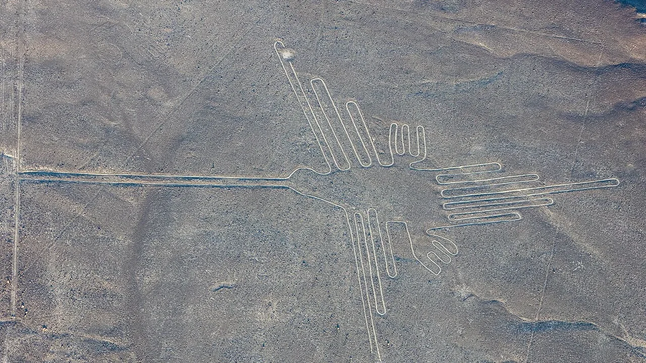
A bird stretches across the desert without lifting a wing. Nearby, lines travel over the ground with a precision that looks startling from above.
The Nazca Lines purpose has invited stories about calendars, water, ritual journeys, and visitors from space. But the construction itself does not require an impossible technology. Moving dark surface stones reveals lighter material below.
The harder question is why people chose to make particular forms in particular places. That question leads away from an alien runway and into a human landscape of routes, gatherings, water concerns, and changing traditions across a very dry part of Peru.
How the designs were made
Many Nazca geoglyphs were created by clearing dark surface material to expose lighter ground beneath. Lines, geometric forms, animals, and other figures belong to a wider archaeological landscape. Their scale can be appreciated from above, but making them did not require aircraft. Ground-based planning and coordinated work provide a practical explanation for construction.
A huge image can seem impossible when you first see it from an airplane. The viewer sees the complete form at once, while its builders could work through smaller, connected tasks.
A line can be laid out using reference points. A larger design can be planned through proportion and careful placement without a person hovering above it.
This does not mean every detail of construction is settled. It means the basic technique fits known human capabilities.
The contrast between dark stones and lighter ground makes the work visible. The dry setting helped many features survive, although survival is not the same as immunity to damage.
Paths, vehicles, weather, and changing land use can disturb the surface. A mark that lasted for centuries can be harmed quickly.
Understanding the method removes a false mystery and preserves a real one. The builders could make the figures. What the figures did within their lives remains a richer question about culture, place, and purpose.
Not every line belongs to one moment
The landscape includes work associated with different periods and traditions, including Paracas and Nasca. Some forms overlap or differ in style and placement. That variation matters because a single explanation may not fit every figure. The lines should be studied as a changing landscape rather than one project completed on one date.
A visitor may use Nazca as one label for everything visible in the desert. Archaeologists need to separate forms that were made under different conditions.
Style offers one clue, but context and dating are also important. A drawing can resemble another without belonging to exactly the same phase.
Overlapping features help establish sequence. If one cuts across another, the relationship may tell us which came later even before an exact date is available.
The differences can change the purpose question. A figure connected with a route may have served differently from a large geometric area.
It is therefore risky to demand one master explanation for the entire site. Human landscapes usually accumulate uses rather than obey one timeless plan.
Recognizing that change makes the desert more interesting. It becomes a record of people returning, altering, and responding to a place. The enduring image from the air can hide centuries of decisions made on the ground.
Why water appears in so many interpretations
Water was a central concern in the arid environment where these communities lived. Researchers have explored relationships among geoglyphs, routes, sacred landscapes, and water-related practices. These links make water a serious line of inquiry, but proximity alone does not prove the exact meaning of every image or ceremony.
In a dry landscape, water connects the practical and the symbolic. Its arrival can affect food, settlement, movement, and the sense of what sustains a community.
That makes it reasonable to ask whether large works on the ground related to hopes, obligations, or gatherings around water.
The question becomes stronger when several forms of evidence agree. Landscape position, associated finds, and wider imagery may support one another.
But a line pointing toward a feature does not tell us the words spoken by people who walked it. An interpretation can be plausible without being complete.
Researchers must also avoid treating every animal as a simple code. A bird or a spider may carry several meanings, and those meanings can vary across time.
The water hypothesis is most useful when it guides specific investigation. It should help predict relationships to look for, rather than become a broad answer applied to every figure because the environment happens to be dry.
The possibility of walking the drawings
Some interpretations emphasize movement through the landscape, including ritual pathways and gatherings. Lines could organize routes or shared actions, while figures might be connected with places people visited. These proposals bring the ground-level experience back into view. They do not require every design to have been walked in the same way.
From the air, a figure looks like a picture. On the ground, it can also function as a place or a route.
That shift matters. The builders and users experienced the landscape with their bodies, moving through distances rather than viewing a complete diagram on a screen.
A pathway can link locations while creating a repeated social action. Returning to it may connect a community with memory, obligation, or a seasonal event.
Associated objects can help test such possibilities. Material left along routes or at important points may provide more information than the outline alone.
Even then, researchers need to distinguish ancient deposits from later disturbance. The attractive idea of a ceremonial walk must fit the actual record.
This approach makes the people visible again. The lines were not necessarily produced only for a distant viewer. They could participate in activities carried out by those living within the landscape, even when a full understanding of those activities remains beyond us.
What early interpretations got right and wrong
Researchers such as Maria Reiche helped document and protect the geoglyphs, while interpretations involving astronomical alignments influenced public understanding. Some alignments may be interesting, but a few matches do not prove a universal calendar. The history of research includes valuable observation alongside ideas that later work has refined or challenged.
A landscape with many lines offers many possible directions. Some will align with the Sun, a star, a mountain, or another feature by chance.
The challenge is to show that a match is meaningful within a larger pattern. Selecting only the successful examples can make almost any complex site look deliberately astronomical.
That does not mean astronomy was irrelevant to ancient life. It means a particular claim needs evidence beyond the general fact that people watched the sky.
The work of documentation remains important even when an interpretation changes. Measurements, maps, and preservation efforts can support research for generations.
Maria Reiche's role in protecting the landscape belongs to that story. A rejected or revised idea does not erase the value of careful observation and advocacy.
The best account of research allows both respect and correction. It recognizes the people who made study possible while keeping the evidence open to methods and questions they did not have available.
A human landscape worth protecting
The geoglyphs are cultural works embedded in a fragile desert setting. Their importance comes from their design, age, relationships, and connection with the communities that made them. There is no archaeological need for an alien construction theory. Protecting the ground preserves the evidence needed to investigate the genuine questions that remain.
The most misleading claim says people could not make a large design unless they could see it from above. That confuses the experience of the modern viewer with the requirements of construction.
It also removes credit from the communities responsible. Skilled planning and cooperation become less visible when every impressive work is assigned to an imagined outsider.
The unresolved questions are already substantial. Why did particular forms appear, how did their uses change, and what relationships connected them with gathering places such as Cahuachi?
Those questions need an intact landscape. A disturbed line can lose information about method, sequence, and association.
A photograph is therefore both an invitation and a limit. It reveals the form while showing only one layer of the history.
The bird remains on the ground. Its stillness is the result of human work and unusual preservation, and the more closely we connect it with the people below the famous aerial view, the more remarkable it becomes.
Frequently Asked Questions
Did the builders need to fly to make the figures?
No. Large designs can be planned and laid out using ground-based methods. Aerial viewing is not a requirement for construction.
Were all the geoglyphs made by one culture?
The landscape includes different phases and traditions, including Paracas and Nasca. That variation is one reason a single purpose should not be assigned to every form.
Are the lines proven to be an astronomical calendar?
Not as a universal explanation for the whole landscape. Astronomical interpretations must distinguish meaningful patterns from alignments expected by chance.